![]()
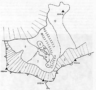
It entirely consists of lower Triassic rock, the so called Triglav unstratified limestone. The numbered geomorphologic units on a special sketch have the characteristics as follows.
1-2 the slope of rock elevations shading the glacier
3-the eastern, now the scree depression
4-the eastern roches mountonees
5a-the central glacier roches mountonees
5b-the lower glacier roches mountonees
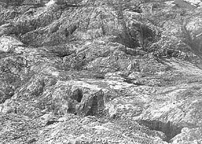
6-the lower icefield basin
7-the upper icefield depression
8-Glava hill
9-the western rock shelves
10-the lower snowfield depression
11-the outer snowfield depression
12-the ridge of Velike Glave
In the summers of 1993 and 1994 (the photographs no. 4 and 5 were taken in 1994) it was for the first time after the beginning of annual surveyance (in 1946) that the contours were laid bare of the lower end of the so called upper glacier depression (7). The greater distance between the lower edge and the Triglav slopes is in the western part. In the central part it is at a distance of 137 m from marker point 14. The bottom is unknown since it was covered with ice even in September 1994. It can be concluded from the conditions on the glacier that the ice gets thinner in the direction towards the slopes of Triglav. In September 1994, the glacier's surface was not curved upwards, as had been the case in previous years. Judging from this, the bedrock has lesser inclination in the central part and at the lower end than the average of the entire icefield (290s) is. On September 24, 1994, all the water from the glacier sank at the lower end. The water which comes running down the rocky slopes in rainy weather, flows over the rock under the glacier, too, all to the first fissure or abyss. At the lower end of the icefield, 1 to 3.5 m higher rock surface rises, which starts a series of unequally high roches moutonees (5a).
The bedrock is also unknown of the eastern under-glacier depression (number 3 on the sketch), which lies at the foot of Kredarica.
The rest of under-glacier bedrock primarily consists of chaotic clusters of roches moutonees. Abraded tops of higher rocks are the common characteristic where on polished surfaces shallow scratches (striations) occur in the direction of ice movement, i.e. in the direction of the greatest inclination (N). The rock is more polished and scratched in the western part than in the eastern part. We did not see scratched rubble, since it is undersized. In between higher roches moutonees there are lower depressions oriented downwards; the surface is less abraded here. In the transversal direction, i.e. in the W-E direction of rock cracks, there are narrower grooves of unequal width, with rubble at the bottom. Several shafts of unknown depths lie open on their bottoms. They slant northwards so that rubble can accumulate on their less inclined southern slopes. Because of their inclination we were not able to establish the depths of the shafts by measuring the echoing time from the bottom after a stone had been thrown down.
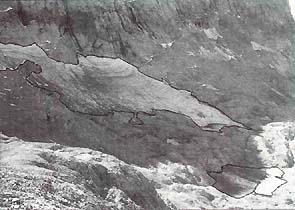
Fig.4 - Rock shelves beneath Veliki Triglav, uncovered more than ever before in the post-war era (upper right-hand corner), and roches mountonees which separate the upper icefield (in the middle) and the lower icefield (lower right-hand corner;only the marginal snow with its white colour is noticeable). The photograph was taken from the position at the edge of Kredarica the slope of which is seen in the lower left-hand corner. The edge lines makes the size of the icefield more distinct.
From all roches moutonees, the first one to appear from under the glacier was the rock with the 2472 m point on top of east glacier roches moutonees (4). In 1993 and 1994, a rock was disclosed above the already mentioned 2472 m point, which continues towards the steep slope of Mali Triglav from which rubble accumulates. In the downward direction from that point a belt of roches moutonees, covered with scree, gets wider and is, in general, the highest of the entire under-glacier relief. From it, the biggest cluster of underglacier roches moutonees extends westwards, called central glacier roches moutonees (7). Their inclination towards the north is 310C. This is more than the surface inclination of the upper icefield was at that time (290C). Whenever the glacier retreated and was smaller in size in past decades, bulging was seen in this place in the longitudinal profile of the entire glacier. It was especially distinct in 1978 (Šifrer, 1986, p. 112, al. 11). From among the tops of the central glacier roches moutonees the first ones to be uncovered from under the ice were those at the lower end, i.e. at the knickpoint towards the basin of the lower icefield.
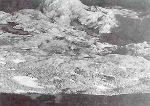
Fig. 5 - The lower third of the picture is occupied with the scree under Mali Triglav. The melting of ice in the rubble basis produces hummocky surface. Behind the scree, there are central under-glacier roches mountonees which first appeared completely from under the ice in autumn 1993 and 1994 (the photograph was taken on september 24, 1994). At the upper edge is Glava hill, The edge of the glacier is highlited with a line.
Between the points 16 and 12A the wide basin (6) of the lower icefield sinks from 10 to 20 m into the complex of roches moutonees. In September 1994 it was filled with water ice, the inclination of which on the rubble cover was only a few degrees. Above the lower end rises 2-3 m higher lower-glacier cluster of roches moutonees (5b) extending towards Glava hill and northwards. North of point 5A, on the first flat plateaux, there are two valley-like depressions which end near Triglav North Face. They are separated by the less continuous series of roches moutonees. The more to the north, the higher they elevate and end near the Prag knick with point 2314 m of Vzhodne glave. In the south they begin on the slope of Kredarica and are called the ridge of Great Roches Moutonees. The relief there is glaciokarstic; however, the glacial traces are less recent than in both the above mentioned depressions by which there are accumulations of morainic rubble on the rocky slope.
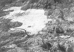
Fig. 6 - The view from Glava hill towards the South where the western part of the glacier is longest. On the rock elevation towards the center of the photograph, there are marker signs denoting the decline of the upper icefield, presented on Fig. 2. The ice on the western edge retreated by 20-30 m from the marker signs made on higher roches mountonees.
In September 1994, the western rock shelves (9) between the steep slopes of Veliki Triglav and Triglav North Face were completely uncovered from beneath the usual snow (9). The inclination of the surface here is greater than in the rest of the under-glacier relief. Therefore, no darker ice has been uncovered from beneath the snow cover after World War II here, and this snowfield was not counted as part of the glacier, also because a few rock tops on which marker signs 9 to 5 had been made, poked up from the snow at the eastern edge of smoother rock shelves. They can not yet be seen on the photographs taken in the previous century (see Meze, 1955). In autumn 1994, two snowfields were disclosed below the steep slope, containing a patch of darker water-ice each, similar to the glacier.
Fig. 7 - From under the glacier above the vertical mouh of the Triglav abyss (lower right hand corner), several openings to caves of unknown depths occured among roches mountonees. At the mouth, they mostly slant northwards.They testify to local, accelerated marginal corrosion by the glacier water.
Corrosion capacity of the water flowing from the glacier, was established through measuring water streams at the top of Triglav abyss. In 1962 this water had 38 mg of carbonate and calcium hardness and 41 mg CaCO3/l of total hardness which is usual of the surface waters running on barren high mountainous area of the Julian Alps (Gams, 1966). The water ran into the abyss across the rock or from the ice base under the snow at the entrance to it. Because the abyss is under the snow cover in winter, and the warmer air inside it ascends, the summer air temperatures amount to about 0.2-0.80C (Gams, 1962, 196l, 1963). Such air temperatures can also be expected in the abysses under the glacier into which snow water percolating through the cracks in the ice is drained. If such water flows over the rubble base which is exposed to moist for a longer time, it is substantially harder. The sample of water coming from the ice-and-rubble mass in the central part of the east- glacier depression, taken in the collapse on September 24,1994, had 81 mg of carbonate and calcium hardness, and 84 mg CaCO3/l of total hardness. The first time that waters from the glacier get into contact with carbonates is under the glacier or at its end. From the area of over 40 hectares such aggressive water drains into rock abysses; on the contact with the ice it moistens rubble and rock, thus corroding them with accelerated speed (Gams, 1962 1963, 1966). In 1993 and 1994, the abundant water stream from the upper icefield caused the concentration of such local, accelerated corrosion on the lower edge of the upper glacier depression which is deepened there by several meters. Judging from this, we can make a conclusion that the glacier had similar size as it had had in the past centuries. This could have been in the warmer Boreal period in the Holocene epoch, or possibly in the Middle Ages when glaciers had been smaller.
Most of the post-war years, the water from the glacier drained into the bedrock at the lower edge of the lower icefield where an explicit basin is situated in west-east direction, that is to say at the lower end of the glacier. Also here, we can presuppose the existence of a similarly long-lasting glacier in the past, of the size of 12-14 ha as had prevailed in the post-war period.
![]()
![]()