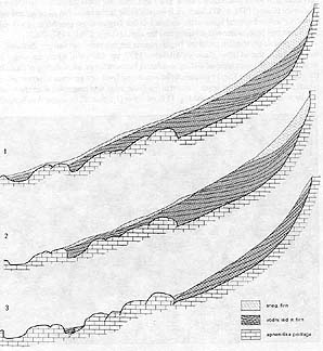
North of the glacier, there are two concaves at the edge of the Triglavski podi (the Triglav plateaux). In the first one, which is closer to the glacier, snowfield still occurred periodically even after World War II, and along its sides, surveyors made first marker signs. Over this depression the ice was still flowing in the second half of the past century towards the Triglav face, above which moraines are preserved north of Glava hill. Close to the then totalizator, rubble of the lateral moraine collapsed in 1962 into a 7 m deep abyss (Gams, 1957). Up to this point, most probably the glacier advanced in 1876; calculating from a map, Richter (1888) assigned it the size of 45.9 hectares. To check this number, we have drawn on a topographic map of l :10,000 a glacier which also covers the rock shelves under Veliki Triglav -- i.e. the bright rocky surfaces under the Triglav crest and the ridge of Kredarica which were already defined by Šifrer (1963) as the highest level of the glacier in the mid-past-century -- and also the two above mentioned concaves on the border plateau. The size of the glacier we have got thus was 35.6 hectares (see also the situation map!), It might well be the size from the middle of the past century when also the Carinthian glaciers were large in size (Lang-Lieb,1993).
No data on structure of the ice in the past century are known, nor can we make any conclusions from the oldest oil painting by Pernhart, possibly made around 1860 (see Meze, 1955, fig.14a), as to where we could place the ice of the glacier in the course of diagenesis of snow crystals and further on in the diagenesis of firn - glacier ice, or, snow - water ice. From the photograph by Pavel Kunaver taken in 1924 (see Meze, 1955, fig.11) no stratified structure of the glacier, characteristic of recent times, can be seen along its longitudinal crevasses. This structure with the typical stripes on the glacier running west-east is visible already in 1947 (see Meze,195 5, fig.18), and also later on whenever the ice was disclosed from the snow cover. Such stratified ice is of darker, greenish-bluish colour. This colour was probably the origin of the popular name given to the glacier - the Green Snow. This darker ice is denser than the old firn or neve. Measurements of density in 1994 were performed by means of a bowl of water into which a lump of ice was dipped, and its volume was measured on the basis of the risen level of water and after it, the same lump of ice was weighed. In summer 1981 the densities of two samples were 0.9 and 0.97. The compacted old snow on the glacier had the density of 0.83 and 0.88 at the end of August 1982 (Gams, 1982, 1983, p. 248; Šifrer, 1986, p.120). On September 24 and 25, 1994, densities of 0.95 and 0.93 were measured at the lower edge of the upper icefield, west of the 2247 m point, and 0.86 under the rubble in the collapse under the water pump beneath Kredarica. The former two densities surpass the characteristic density of firn (which is 0.8-0.85) and the density, characteristic of glacier ice (i.e. 0.91- Wilchelm, 1975, p. 135). They are closer to the density of water ice. The genesis of such mass is supposed to be a result of the melting of surface snow, water penetration to the impermeable basis, the flow over it and periodical freezing of water soaked snow mass. Therefore, there are fewer air bubbles in it than in glacier ice (Gams, 1978,1983). Such ice is usually found in the base of snow cover and was actually disclosed several times at the entrance to the Triglav abyss (see Meze,1955, fig. 20). From this base, water was dripping into the abyss (Gams, 1963, 1957, 1962).
![]()
![]()
![]()